
How to measure distance on a map
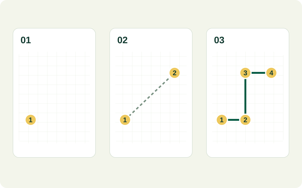
- Find the start. Start the distance tool above, move to the location and zoom until the path is easy to distinguish.
- Place the first two points. Mark the start and next location. Two points describe a direct segment between them. Stop at two points if that separation is all you need.
- Follow changes of direction. Add intermediate points along bends to measure a path, field access track or boundary edge. The tool adds the segments you draw; it does not choose a route for you.
- Review every segment. Make sure none cut across a corner, water, a building or a bend that your intended path follows.
- Read the total with its unit. Keep the path and measurement purpose together when you record the estimate. For a return trip, double the length only if you will follow exactly the same path back.
A direct line and a traced path answer different questions
Between two points
Use a direct segment to compare the separation of two positions. It does not establish whether you can travel between them along that line.
Along a path
Use a sequence of segments to follow a winding track. More points around bends reduce the amount of curve that gets cut off.
Around an area
A complete boundary is a perimeter. If you also need the surface inside it, use the area calculator.
A manually traced line is not an automatically calculated driving route. Check access, barriers and the actual route separately. Map distance alone also cannot predict journey time without assumptions about speed, terrain and stops.
Add the segments, then convert the unit
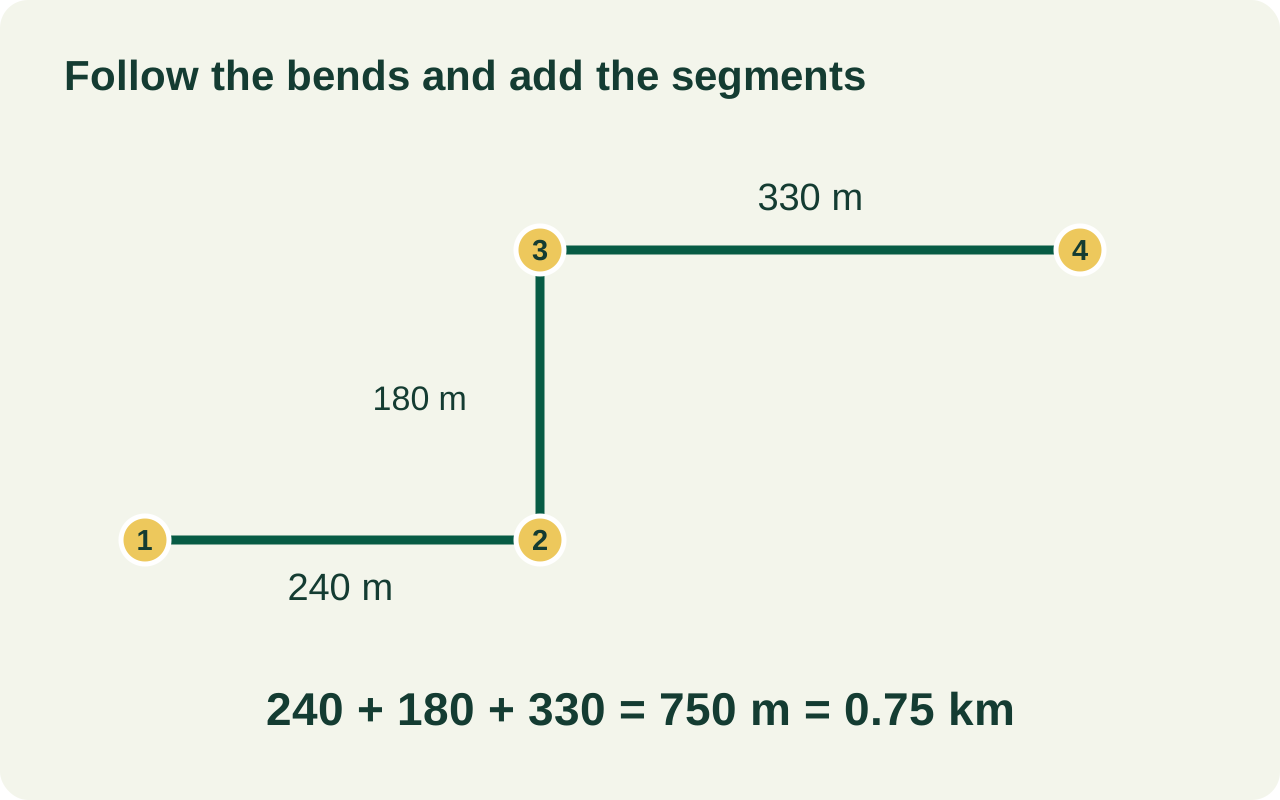
Illustrative example: a three-segment track measuring 240 m, 180 m and 330 m totals 750 m. Dividing by 1,000 gives 0.75 km; dividing by 1,609.344 gives approximately 0.466 miles.
| Unit | Equivalent length |
|---|---|
| 1 kilometre | 1,000 metres |
| 1 mile | 1,609.344 metres |
| 1 foot | 0.3048 metres |
For a curved path, a few long straight segments tend to underestimate its length. Zoom in and follow meaningful bends, while avoiding extra points caused by image blur. Point placement and map alignment still limit the precision of the estimate.
Distance measurement questions
Can I measure a curved route?
Approximate it with several short segments. Add points around the curve and check the whole line; a single straight segment between its ends will miss the bend.
Is this driving distance or a road route?
No. You place the points yourself. A traced line does not check one-way streets, turn restrictions, private access or traffic. For a car journey, use a directions service and check that its route is suitable for your vehicle.
Does the line include hills and elevation?
Treat a traced map distance as a horizontal map estimate, not the full length along the ground surface. Travel over steep or uneven ground can be longer; use an elevation-aware method if you need ground distance.
Can this tell me how much fencing to buy?
It can support an early length estimate. Check the boundary, slope, gates, openings and on-site dimensions before ordering materials, and allow for the installation requirements. A visible edge does not establish the legal property boundary.
Mixed units: convert before adding the segments
A field-access line has three recorded sections: 0.35 km, 240 m and 0.11 km. First put every section in metres; adding the displayed numbers without their units would not give the route length.
| Section | Recorded value | Value to add |
|---|---|---|
| First section | 0.35 km | 350 m |
| Second section | 240 m | 240 m |
| Third section | 0.11 km | 110 m |
The total is 350 + 240 + 110 = 700 m = 0.7 km. If your notes and the traced total disagree, compare the unit on each recorded section before changing the line. For an on-site measurement workflow, see the guide to walking a boundary with GPS.
A material run and an inspection walk can have different totals
Consider a 300 m access run from an entrance to a junction, with two branches of 120 m and 80 m. Each distinct run counts once for a simple pipe-length tally. An inspection that visits both branch ends and returns to the entrance along the same runs travels each section twice.
| Run | Counted once | Out and back |
|---|---|---|
| Entrance to junction | 300 m | 600 m |
| First branch | 120 m | 240 m |
| Second branch | 80 m | 160 m |
| Total | 500 m | 1,000 m |
Measure each run separately for the 500 m tally; trace the full inspection walk for the 1,000 m travel total. Connection details or installation allowances would be separate inputs to a material estimate. Before adding a repeated section, decide whether you are counting material in place or distance travelled.
Planning a fence instead?
A boundary has different assumptions from this branched example. Read why area alone does not determine fence length, then use the rectangular fence calculator if its length, width and centred-gate model matches your plan. Enter those dimensions yourself; this traced line is not transferred automatically.